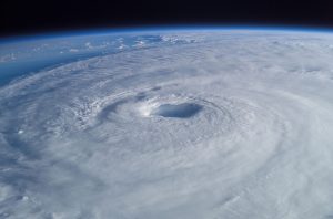
The first named hurricane in the North Atlantic has gotten a major jump start on the 2024 hurricane season, with Hurricane Beryl reaching category-4 strength less than 48 hours after it was classified as a tropical storm; its rapid intensification fueled by record-warm waters in the mid-Atlantic. The cyclone reached category-4 strength by Sunday morning, threatening the eastern Caribbean with 130 mph (215 km/h) winds, and is expected to make landfall in the Windward Islands on Monday – according to the National Hurricane Center.
Beryl started as Tropical Depression Two over the central Atlantic on June 28, but warm surface waters and low wind shear caused it to strengthen into a tropical storm in less than six hours; less than 24 hours later the storm had strengthened into a category-1 hurricane with sustained winds of 85 mph (137 km/h); and by the morning of June 30 had surpassed forecasts with 121 mph (195 km/h) winds—a category-4 storm. Hurricane warnings have been issued for numerous Caribbean islands, including Barbados, Grenada, St. Lucia and St. Vincent and the Grenadine Islands, with tropical storm warnings issued for Martinique and Tobago.
Beryl’s rapid intensification is being driven by record-warm waters across the Atlantic, the Caribbean and the Gulf of Mexico, exhibiting temperatures typically not seen until later in the season.
“If you asked the water in the Caribbean Sea what day it was, it would guess September 10,” according to a tweet posted by Brian McNoldy, a senior research scientist at the University of Miami’s Rosenstiel School. “You’d think the shock value of this would wear off, but it’s becoming MORE shocking!”
Along with the formation of La Nina conditions in the equatorial Pacific, warm surface waters prompted the National Oceanic and Atmospheric Administration to forecast a potentially record-breaking hurricane season for the North Atlantic, with the expectation of at least 13 hurricanes to form over the 2024 season.
Beryl is the strongest storm to form so far east of the Windward Islands in June, according to Colorado State meteorologist and research scientist Phil Klotzbach; historically, only five major hurricanes with wind speeds in excess of 111 mph (179 km/h) have been recorded in the Atlantic before the start of July.
“It’s astonishing to see a forecast for a major (Category 3+) hurricane in June anywhere in the Atlantic, let alone this far east in the deep tropics, ” explained Michael Lowry, a former National Hurricane Center specialist.
Despite the intensity forecast for Beryl’s winds, the storm is expected to lose strength by Wednesday, due to higher wind shear conditions over the Caribbean: these conditions can decapitate the cloud tops of hurricanes, disrupting the core of the storm that lends strength to the winds circling the massive cyclone.
Subscribers, to watch the subscriber version of the video, first log in then click on Dreamland Subscriber-Only Video Podcast link.
UPDATE: Beryl is now the earliest category-4 storm on record, beating 2005’s Hurricane Dennis, not reaching cat-4 until July 8 of that year:
https://www.theguardian.com/world/article/2024/jun/30/hurricane-beryl-earliest-category-4-on-record
Beryl’s rate of intensification is also, well, intense: when I finished the first draft of this article about 16 hours ago, it was only forecast to become a catergory-3 storm; barely 11 hours later the storm surpassed that to hit catergory-4 status.
Hi Matthew! I haven’t seen you since the orb -aura fest at the Ohio snake mound with Jim Boyle!
Are you in CA or in Canada these days? Love the news and dreamland ..long time subscriber.
My spouse remarked about the sudden intensification this morning, and how the forecasters weren’t explaining it. I told him that they can’t, but won’t admit that the old climate and weather models no longer work. It’s been getting worse for at least the last ten years, and all you have to do is look at the intense heat in places in the USA right now that are breaking records to see how bad it is. It was actually cooler here in Central Texas than places farther north until a few days ago.
I just read that, “Hurricane Beryl makes landfall, just shy Category 5 strength.” Actually 7 miles shy of a category 5 hurricane.
The reality is we will need multiple colossal human suffering disasters to make the shallow general public wake up and force politicians to do something.
There are so many factors, including dust from the Sahara Desert, in how these things develop. In Beryl’s case, it’s a big factor.
https://www.statesman.com/story/news/state/2024/07/01/saharan-dust-plume-texas-why-are-skies-hazy-hurricane-beryl/74266348007/
Here in Texas in Texas, we get a double whammy in the form of sand coming in from the Sahara, and earlier in the year with the ag burning in Mexico and Central America. Whether it’s Saharan dust, or smoke from the south, it adds pollutants to our skies and health alerts.